
Austin Parks and Recreation Department, Oakwood Cemetery Chapel, exhibit “To Emancipate”.
The Communities
Early History of Waller Creek
Freedpeople founded the Red River Street community along lower Waller Creek in the late 1860s after record flooding destroyed much of the existing properties on the land bordering Waller Creek. The community was bounded by Red River Street on the west, Sabine Street on the east, 8th Street on the south, and 13th Street on the north.(11) Just four blocks east of the state capitol building, and bisected by Waller Creek, it was located squarely along the floodplains of the creek’s main branch. Though freedpersons had lived on these lands for years prior, the early community was foregrounded in part through the subdivision and sale of six lots in Block 140 of the City of Austin by Reverend Charles Gillette of the Episcopal Church beginning in 1867. Gillette purchased these lots from his mentee, Swedish colonist Swante Magnus Swenson, on July 30th, 1858, for $1, then subdivided and sold them through his lawyer, James H. Raymond, following the Civil War.
Five freedpersons purchased Gillette’s six lots in Block 140 through his lawyer, Raymond, before his passing in March of 1869. First, John Hannig/Henning (b. 1800, NC) purchased lot 7 in Block 140 from Charles and Mary Gillette for $100 in gold specie on January 10th, 1867.(12) Freedwoman Martha Hedespeth (b. 1840, TN) purchased lot five from Block 140 for $100 in gold specie on May 28th of 1868.(13) Martha worked as a washerwoman and lived with her husband, Green Hedspeth (b. 1842, VA), a carpenter, and their two children, Tempy and Joseph. Then, Joseph Carter purchased lot one from Block 140 for $75 from the Gillettes on December 16th of 1868.(14) On the same day, John Hannig purchased another lot, lot 6, from Block 140 from the Gillettes for $100.(15) Next, Vince McReavey purchased lot 8 from Block 140 for $100 from the Gillettes on January 20th of 1869.(16) Finally, freedwoman Brista/Bresla Garrett purchased lot 4 for $100 on February 18th of 1869.(17)
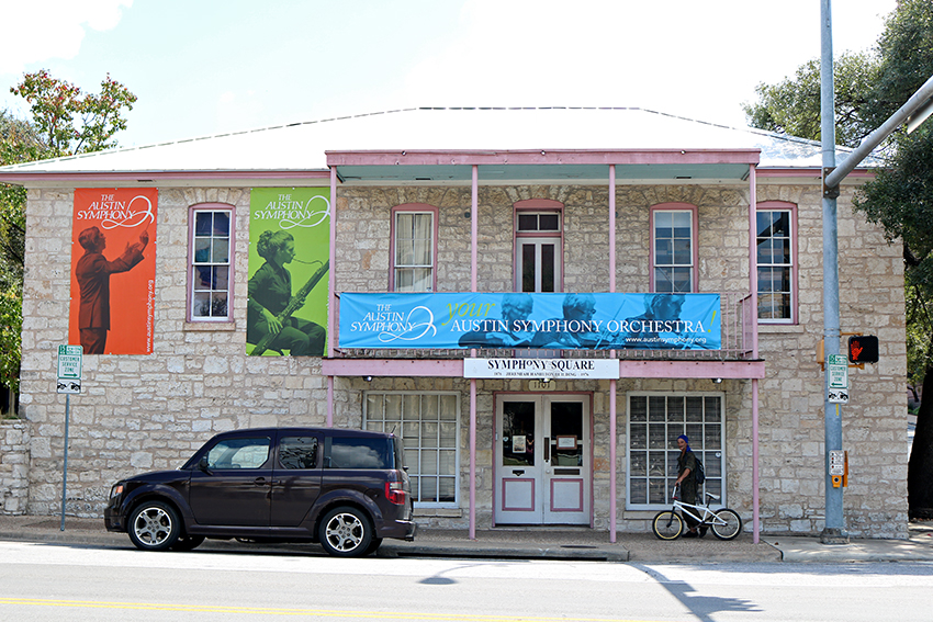
Though many of the aforementioned families, such as the Hedspeths and the Hannings, lived on their lots through the turn of the century, some quickly subdivided or sold off their properties, thereby growing the community. For example, Joseph Carter and his wife Ellen sold lot one from Block 140 to freedman Edward Aldridge (b. 1840, KY) for $1 in August of 1869, just a year after they’d purchased it.(18) Aldridge and his wife Dicy then sold a portion of that lot to freedman Joseph Aheart (b.1851, TN) on September 5th of 1869 for $35.(19) Aheart lived there with his wife Ellen (b., TN) and son Richard, and sold the southwest corner of lot 1 from Block 140 to Jeremiah J. Hamilton (b. 1838, TN) on January 8th of 1871 for 10 specie dollars.(20) One of Central Texas’ most prominent Black political leaders, Hamilton had advocated for freedpersons' economic, social, and educational rights as an educator and organizer and had a seat on Texas’ House of Representatives in the state’s twelfth legislature, which he served from 1870 to 1871 on behalf of Bastrop and Fayetteville counties.(21) It appears Hamilton, along with his wife Ellen (b. 1855, KY) and their children, previously lived two blocks north on a pair of lots he’d purchased in Block 167 on July 16th, 1870.(22) Historical records indicate Hamilton purchased land from Block 140 to construct an impressive two-story limestone triangular stone building in 1871, which could later be used as a residence and a general store.(23)
The community had a school in the mid-1870s, which enrolled approximately 500 students by 1876.(24) It was known as the Evans’ Community School by 1881, when it had 148 students enrolled, though it was later renamed the Central Grammar School in 1885.(25) The Evans Community school, likely named for educator Elizabeth Evans-Garland, “laid the groundwork for the American Missionary Society’s founding of Tillotson Collegiate and Normal Institute in Austin in 1877.”(26) The school was led by Principal W. T. Phillips for several years, and by 1888 was led by Principal E. L. Blackshear, assistant Miss Ross, and assistant for primary classes Miss Clara Smith.(27) Interestingly, the school held classes in the temporary Capitol building at the intersection of Congress and 11th from 1888, along with Austin High, until the building caught fire in 1899.(28)
[11] Jane Manaster, “The Ethnic Geography of Austin Texas: 1875-1910,” master’s thesis, The University of Texas at Austin, May 1986.
[12] Travis County Clerk’s Office, Deed Record Q, page 732-733
[13] Travis County Clerk’s Office, Deed Record R, page 399-400
[14] Travis County Clerk’s Office, Deed Record R, page 497-498
[15] Travis County Clerk’s Office, Deed Record R, 508
[16] Travis COunty Clerk’s Office, Deed Record R, page 544
[17] Travis COunty Clerk’s Office, Deed Record S, page 168
[18] Travis COunty Clerk’s Office, Deed Record S, page 260
[19] Travis County Clerk’s Office, Deed Record S, 326
[20] Travis County Clerk’s Office, Deed Record U, pages 434-435
[21] Alwyn Barr, “Jeremiah Hamilton: Pioneering Black Leader in Texas,” Texas State Historical Association, Updated September 17, 2025
[22] 1870 U.S. Census, Travis County, page 98
[23] [Historic Marker Application: The Jeremiah Hamilton House], Texas Historical Commission, page 7.; 49; Book U, page 435 L. W. COllins
[24] Michelle Mears, And Grace Will Lead Me Home: African American Freedmen Communities of Austin, Texas, 1865–1928 (Lubbock: 2009): 63
[25] Michelle Mears, 64
[26] HIistoric Context Survey of Lower Walller Creek, Waller Creek Conservancy, 65
[27] Austin American Statesman, “School Board Meeting,” September 12, 1888
[28] AAS, Old School Was First City High, March 22, 1956
Map provided by Austin Parks and Recreation Department, Oakwood Cemetery Chapel, exhibit “To Emancipate”.
Click on the map to zoom in and explore a specific community.To view a full list of all communities, click the “i” icon in the top-left corner of the map.
